Tracking ships around the world in real-time.
Monitoring. Search. AIS Data.
Current Traffic
-
 Mh3 Fadista
2sec agoarrived inLisbon
Mh3 Fadista
2sec agoarrived inLisbon
-
 Preference
2sec agoleftLos Angeles
Preference
2sec agoleftLos Angeles
-
 Khazar-2
6sec agoarrived inQaradag
Khazar-2
6sec agoarrived inQaradag
-
 Vb Titan
6sec agoarrived inAlgeciras
Vb Titan
6sec agoarrived inAlgeciras
-
 Princesse Valerie
7sec agoarrived inLorient
Princesse Valerie
7sec agoarrived inLorient
-
 Go Vakker Asta
10sec agoarrived inFredrikstad
Go Vakker Asta
10sec agoarrived inFredrikstad
-
 Uwcon Fast
12sec agoleftCity of Singapore
Uwcon Fast
12sec agoleftCity of Singapore
-
 Hosta
13sec agoleftDordrecht
Hosta
13sec agoleftDordrecht
-
 Michael B
22sec agoarrived inBerlin
Michael B
22sec agoarrived inBerlin
-
Fru Andersen
22sec agoarrived inKristiansand
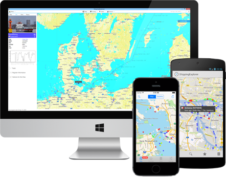
Search and Track Positions of Ships in Real-Time
AIS Monitoring
ShippingExplorer uses AIS data (automatic identification system) to determine positions and provide exhaustive information about ships. Based on AIS, our system builds a map of ship movements in real-time on seas and oceans and allows for locating and detailed monitoring of ships and ports.
Map with AIS Data
Our application has several map providers and color schemes to show AIS data. Additional layers with information about weather, waves, and wind are available.
Route Planning
ShippingExplorer offers the tools to plan routes with ETA in ports and bunker calculations.
Locate Ships in Real-Time
The program allows to search for ships based on a variety of criteria (by name, MMSI, IMO, type, register information, destination, etc.). For example, allowing you to see all passenger ships headed to Lisbon.
Alerts
We have a flexible configuration system for notifications via SMS and e-mail for tracking ship positions and behavior in real-time. For example, you can be notified when your ship enters a specific area, changed its speed or course.
Archive
Besides positions of ships on our maps in real-time, ShippingExplorer has archived information about ships for several years.
 luisprieto
 brander
 Benjamin


