Tracking ships around the world in real-time.
Monitoring. Search. AIS Data.
Current Traffic
-
 Kung Ring
1sec agoarrived inStockholm
Kung Ring
1sec agoarrived inStockholm
-
 Gourmet Dining
3sec agoleft
Gourmet Dining
3sec agoleft Hong Kong
-
 Adis
4sec agoarrived inNovorossiysk
Adis
4sec agoarrived inNovorossiysk
-
 Mar Ficas
6sec agoleftVigo
Mar Ficas
6sec agoleftVigo
-
 Zeycan Y
9sec agoarrived inGemlik
Zeycan Y
9sec agoarrived inGemlik
-
 Pilot 01
10sec agoarrived inNiteroi
Pilot 01
10sec agoarrived inNiteroi
-
 Pato Real
13sec agoleftSetubal
Pato Real
13sec agoleftSetubal
-
 Altefaehr
13sec agoarrived inStralsund
Altefaehr
13sec agoarrived inStralsund
-
 Woo Chan
14sec agoarrived inBusan
Woo Chan
14sec agoarrived inBusan
-
Yoroz 8
14sec agoleftTuzla
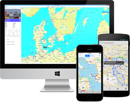
Search and Track Positions of Ships in Real-Time
AIS Monitoring
ShippingExplorer uses AIS data (automatic identification system) to determine positions and provide exhaustive information about ships. Based on AIS, our system builds a map of ship movements in real-time on seas and oceans and allows for locating and detailed monitoring of ships and ports.
Map with AIS Data
Our application has several map providers and color schemes to show AIS data. Additional layers with information about weather, waves, and wind are available.
Route Planning
ShippingExplorer offers the tools to plan routes with ETA in ports and bunker calculations.
Locate Ships in Real-Time
The program allows to search for ships based on a variety of criteria (by name, MMSI, IMO, type, register information, destination, etc.). For example, allowing you to see all passenger ships headed to Lisbon.
Alerts
We have a flexible configuration system for notifications via SMS and e-mail for tracking ship positions and behavior in real-time. For example, you can be notified when your ship enters a specific area, changed its speed or course.
Archive
Besides positions of ships on our maps in real-time, ShippingExplorer has archived information about ships for several years.
 Benjamin
 brander


